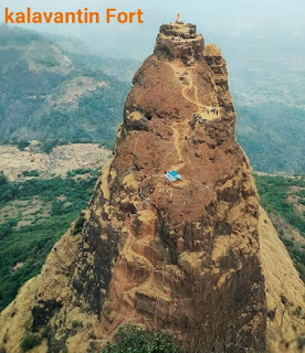
The pinnacle is reached by a flight of stairs, although little is known about the history of the building. Local guides claim that it was constructed for a queen named Kalavantin in the 15th century, roughly at the same time as the nearby Pragalbhdad.
 |
| Kalavantin Durg |
1.How is difficult
This trail is a bit tricky to navigate due to the rock-cut steps and steep slope. However, the difficulty level is medium, requiring basic physical endurance. Do note that the Kalavantin Durg trail becomes tougher to tread through during the monsoon as the steps become slippery.2.Is Kalavantin Durg safe?
Although Kalavantin Durg looks very dangerous for beginners, it's completely safe for the trek. Still, you need to take extra precaution while climbing the rock-cut steep steps.3.How many steps in kalavantin
16,000 Steps 2300 feet My Trekking Story Travel Blog Kalavantin Durg.4.Who built
Durg' in Marathi translates to fort. According to local sources, queen Kalavantin had built the structure in the 15th century.
5.How long does it take
Kalavantin Durg trek is around 3.7 km long and takes about 3 -4 hours to reach the top from the base village. The final climb is quite challenging, so make sure you carry enough food and water along with you.
6.Best time to visit
Time: October-May. Timings: 5:00 am to 3:00 pm. Price: Trek cost per person: Rs. 800.
7.Protocal
After some death, the local administration instituted new rules to ensure safety of the trekkers. According to the new rules, each trekker had to register with the administration by paying an entry fee of ₹ 20, and providing their personal details.
No entry was allowed in the area during dark hours of 5pm-6am. During other hours, the entry was allowed only when accompanied by a local guide, which would cost ₹ 50.
The administration trained 50 local villagers as guides. The trekkers were also banned from using plastic bags or plastic bottles.
8.Located
Prabalgad Fort, also known as Kalavantin Durg (Kalavantin Fort), is located between Matheran and Panvel in the Indian state of Maharashtra, at an elevation of 2,300 feet in the Western Ghats.
It is located on a plateau very close to Matheran, but unlike Matheran Prabalgad fort does not have a good source of water supply.
It was known as Muranjan until it was taken over and renamed by the Maratha forces under king Shivaji maharaja rule.

